mercoledì 24 giugno 2009

The magic of Venice of the North: St. Petersburg


Three hundred bridges, forty-four islands, a sublime architectural heritage, from May to July, the White Nights of magic and history, the life, the works of some of the writers and poets of the most important modern literature. St. Petersburg which stands at the mouth of the Neva River on the Baltic Sea and borders with Finland and Estonia, has about four million people (most Orthodox), of which 15% live in Kommunalka, apartments shared by several families.
Tolstoj environment in this city much of its Anna Karenina, Ivan Turgenev wrote Memoirs of a hunter, and Dostoevsky (who called his home "a sublime chaos, universal and orderly ') atmosphere Crime and Punishment focuses on the dark side of the city and turbid on the characters who populate.
St. Petersburg is the Venice of the North, is a city of water. The Neva and channels are well integrated into inhabited areas crossed by bridges and embankments that make it even more fascinating. Great attention to detail and street tree. There are many avenues and rights, the gardens, parks, monuments and decorative sculptures. The architecture that attracts the most is that of the eighteenth century and that of the imperial city deliberately degraded Stalinist architecture and subsequently restored by Cruscev and Brezhnev.
To see absolutely the Fortress of St. Peter and Paul, Cathedral of Resurrection, the institute Smonly, the Palace Square with the Winter Palace, Nevsky Prospect, Palace of the Stock Exchange. And again. The seat of state Dekabristov Square with the monument to Peter the Great Square of the Arts, the Castle of Engineers. Among the most important churches are St. Issac's cathedral, the Cathedral of St. Nicholas and the Church of the Savior on Spilled Blood with its colorful tile art nouveau announces that conquered the city in the late and makes look so impressive to the cathedral of St. Basil of Moscow.
The premises are best Imbir, Restoran, Sukawati, Onegin, Che. To sleep better search for mini hotel in the historic center solutions that offer a pleasing average prices. Among these Angleterre, Corinthia Nevsky Palace Hotel, Hotel Dostoevsky.

Rosa Di Ponzio

La magia della Venezia del nord: San Pietroburgo


Trecento ponti, quarantaquattro isole, un patrimonio architettonico sublime, da maggio a luglio le magia delle Notti Bianche e la storia, la vita, le opere di alcuni tra gli scrittori e i poeti più importanti della letteratura moderna. San Pietroburgo che sorge alla foce del fiume Neva sul Mar Baltico e confina con la Finlandia e con l'Estonia, ha circa quattro milioni di abitanti.
Tolstoj ambientò in questa città buona parte della sua Anna Karenina, Ivan Turgenev scrisse Memorie di un cacciatore, e Dostoevskij (che definiva la sua patria «un caos sublime, universale e ordinato») ambientò qui Delitto e castigo centrato sul lato oscuro della città e sui torbidi personaggi che la popolavano.
San Pietroburgo è la Venezia del Nord, è una città d'acqua. La Neva e i canali sono ben integrati negli spazi abitati attraversati da ponti e da argini che la rendono ancora più affascinante. Grande cura dei dettagli e delle strade alberate. Ci sono i viali lunghi e diritti, i giardini, i parchi, le sculture monumentali e decorative. L'architettura che attrae di più è quella del Settecento e dell'Ottocento, quella della città imperiale volutamente degradata dall'architettura stalinista e restaurata successivamente da Cruscev e Breznev.
Da vedere assolutamente la Fortezza di San Pietro e Paolo, la Cattedrale della Resurrezione, l'istituto Smonly, la Piazza del Palazzo con il Palazzo d'Inverno, la Prospettiva Nevskij, il Palazzo della Borsa. E ancora. La sede dell'Università statale, Piazza Dekabristov con il monumento a Pietro il Grande, Piazza delle Arti, il Castello degli Ingegneri. Tra le chiese le più importanti sono la Cattedrale di Sant'Isacco, la cattedrale di San Nicola e la Chiesa del Salvatore sul Sangue Versato che con le sue tegole colorate annuncia l'art nouveau che conquistò la città alla fine dell'Ottocento e la fa assomigliare in modo strabiliante alla cattedrale di San Basilio di Mosca.
I locali migliori sono Imbir, Restoran, Sukawati, Onegin, Che. Per dormire meglio cercare i mini hotel del centro storico che offrono soluzioni gradevoli a prezzi medi. Tra questi Angleterre, Corinthia Nevskij Palace Hotel, Hotel Dostoevsky.


Visualizzazione ingrandita della mappa


Rosa Di Ponzio

giovedì 11 giugno 2009

Streets of Morocco


Stages walked in Morocco:

440 Km From Ceuta in El Jadida (visit the beautiful city and great Portuguese grilled or fried fish outside the walls to "neutral" figure of about € 3). The International Camping is coming from the north, 2 km from El Jadida (in one of Morocco, the lack of signs of camping). If this step seems too long, you can leave the head in Kenitra and a Mehdiya Plage (Camping International) or Salè (Camping outside the walls the same name), good for a visit to Rabat and obtaining visa at the various embassies.
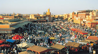
- Km 290, following the coastal road, less traffic, pan and sliding up to Safi for lunch and arrive in Essaouira, where in my opinion it is mandatory to stop at least one day, arriving in this beautiful city, you will find the camping at the first intersection turn left. Excellent choice of inns, hotels, restaurants e. .. fabulous grilled fish at the port with approximately € 5 each.
- 200 Km Transfer to Agadir, with temperate climate throughout the homonymous bay, even in winter, half of the legendary retired European motorhome. Camping International entered the city on the left, not on the sea and usually full of Germans with enormous satellite dishes and drawings Bedouins (very fashionable) on the sides of the camper by the sympathetic Chakir, said Raphael. For lovers of free camping segnalo a colony of Germans on the beach 20 km. north of Agadir, in any case, aktung to ladruncoli and, in the city, it would be prudent to leave the car in a guarded parking authorized.
- 250 Km From Agadir to Sidi Ifni, a former Spanish colony, stop and visit the beautiful Tiznit and subsequent diversion on the coastal road. Great views over the Atlantic, especially 10 km. policy (Plage el Gyra) with a rare view from the cliff and the possibility of free camping. The organized camping, not exceptionally beautiful, it will be in town and a good restaurant on the ramparts.
- 540 Km Stage with arrival at Laayoune. Pulled almost mandatory there is nothing to see on the course, except a beautiful creek 50 km. first of Tan-Tan. From here begins the former Western Sahara Spanish, there are more checks by the Police and the Royal Gerdarmerie that have so far ignored the tourist. Suggest you bring several photocopies of your passport, driving license (by the way, that international travel this is not essential), book circulation and some photos. A Laayoune find many workshops for the first controls on cars, cheap oil changes, etc.., 20 km. Laayoune after, turn right at Foum el Oued. Camping le Champignon bungalow with sea or freely (here there are no phones to foreign countries, so if you need it, calls from Laayoune.
- Another 525 km long stage basically boring Dakla up to 25 km. before you left a post Controle military and then a beautiful cove not visible from the road, excellent for camping free and completely safe, with a few Bedouin tents. If you are camping you will find organized 2 km. before Dakla, left, (Moussafir), many restaurants in the center and several hotels. Recommend not to get in the dark because the road, in the last stretch of the peninsula is quite narrow and bruttina.
- 440 Km From Dakla a Nouadibou. Better to start early in the morning. The road immediately turns on the track, although moving, and we must be careful with stones fired from the tires of cars and not be sure of finding the oil in the distributor's path, the operations of the border to Bir Guandouz are usually fast. You are then exited from the Western Sahara Spain, already the scene of a hard comparison between Morocco on the one hand and the Polisario Front backed by Libya and Algeria on the other, with the sympathies of Spain, they say. Politically speaking, Mauritania would also a portion of this vast and rich territory, but now the situation is quiet and totally controlled by Morocco, which has found perhaps the gold (as well as platinum, minerals, phosphates, fisheries and more) in ' former Rio de Oro, but also a series of problems involving a major military engagement, political and assistance in the ongoing recovery. Important! Is no longer the convoy, no one dare to leave the track: they say that the area is mined and ... agrees not found.
From Ceuta to Nouadibou before the Mauritanian town, you have almost 2700 kilometers route.

Rosa Di Ponzio

lunedì 1 giugno 2009

ATTRAVERSAMENTO DEL MAROCCO


Le tappe percorribili in territorio marocchino:

Km. 440 Da Ceuta a El Jadida (visita alla bella città portoghese e notevole grigliata o frittura di pesce fuori le mura alla " folle " cifra di circa 3 €). Il Camping Internationale si trova, venendo dal nord, a 2 km prima di El Jadida (uno dei nei del Marocco, la scarsa segnaletica dei camping). Se questa tappa vi sembra troppo lunga, potete uscire dall'autostrada a Kenitra e dirigervi a Mehdiya Plage (Camping Internationale) oppure a Salè (Camping omonimo fuori le mura), ottimo per la visita di Rabat e l'ottenimento di eventuali visti presso le varie Ambasciate.
- Km. 290 Seguendo la strada costiera, meno trafficata, panoramica e scorrevole, fino a Safi per il pranzo e arrivo ad Essaouira dove a mio parere è obbligatoria la sosta di almeno un giorno; arrivando in questa bellissima città, troverete il Camping al primo incrocio girando a sinistra. Ottime possibilità di scelta fra pensioni, hotel, ristoranti e...favolose grigliate di pesce al porto con circa 5 € a testa.
- Km. 200 Trasferimento ad Agadir, con clima temperato in tutta la baia omonima, anche d'inverno, meta mitica del pensionato europeo camperista. Camping Internationale entrando in città a sinistra, non sul mare e normalmente affollato di tedeschi con enormi parabole satellitari e disegni beduini (di gran moda) sulle fiancate dei camper ad opera del simpatico Chakir, detto "Raffaello". Agli appassionati del campeggio libero segnalo una colonia di tedeschi sulla spiaggia 20 km. a nord di Agadir; in ogni caso, aktung ai ladruncoli e, in città, sarà prudente lasciare la macchina custodita in un parcheggio autorizzato.
- Km. 250 Da Agadir a Sidi Ifni, ex colonia spagnola; sosta e visita alla bella Tiznit e successiva deviazione sulla strada costiera. Panorami notevolissimi sull'Oceano Atlantico, soprattutto 10 km. prima dell'arrivo (Plage el Ghira) con rara veduta dall'alto della scogliera e possibilità di campeggio libero. Il camping organizzato, non eccezionalmente bello, lo troverete in città e un buon ristorante sui bastioni.
- Km. 540 Tappa con arrivo a Laayoune. Tirata quasi obbligatoria non essendoci nulla da vedere sul percorso, tranne una bella insenatura 50 km. prima di Tan-Tan. Da qui comincia l'ex Sahara Occidentale Spagnolo, si moltiplicano i controlli della Polizia e della Gerdarmerie Royale che hanno finora ignorato il turista. Suggerisco di portare diverse fotocopie del passaporto, della patente (a proposito, quella internazionale in questo viaggio non è indispensabile), libretto di circolazione e alcune fototessera. A Laayoune troverete tantissime officine per i primi controlli alle macchine, cambi d'olio convenienti, ecc.; 20 km. dopo Laayoune, girare a destra per Foum el Oued . Camping le Champignon con bungalow oppure sul mare liberamente (qui non ci sono telefoni per l'estero, per cui, se ne avete bisogno, chiamate da Laayoune.
- Km. 525 Altra lunga tappa sostanzialmente noiosa fino a Dakla; 25 km. prima dell'arrivo troverete a sinistra un Post Controle militare e, subito dopo, una bella insenatura non visibile dalla strada, ottima per il campeggio libero e del tutto sicura, con un paio di tende beduine. Se invece cercate il campeggio organizzato lo troverete 2 km. prima di Dakla, a sinistra, (Moussafir); molti ristorantini in centro e alcuni hotel. Consiglierei di non arrivare al buio perché la strada, nell'ultimo tratto della penisola, è piuttosto bruttina e stretta.
- Km. 440 Da Dakla a Nouadibou. Meglio partire presto al mattino. La strada si trasforma subito in pista, anche se scorrevole, e bisogna fare attenzione ai sassolini sparati dai pneumatici delle macchine e non essere certi di trovare il gasolio nell'unico distributore sul percorso; le operazioni di frontiera a Bir Guandouz sono normalmente veloci. Siete quindi usciti dall'ex Sahara occidentale spagnolo, già teatro di un duro confronto fra Marocco da una parte e Fronte Polisario appoggiato da Libia e Algeria dall'altra, con le simpatie della Spagna, dicono. Politicamente parlando, anche la Mauritania vorrebbe una porzione di questo vasto e ricchissimo territorio, ma attualmente la situazione è tranquilla e del tutto controllata dal Marocco che ha trovato forse l'oro (oltre che platino, minerali, fosfati, pesca e altro) nell'ex Rio de Oro, ma anche una serie di problemi che comportano un grosso impegno militare, politico e di assistenza nell'area in corso di ripopolamento. Importante! Non essendoci più il convoglio, nessuno si azzardi ad uscire dalla pista: dicono che la zona è minata e ... non conviene accertarlo.
Da Ceuta a Nouadibou, prima città mauritana, avrete pressappoco percorso 2700 chilometri.


Visualizzazione ingrandita della mappa


Rosa Di Ponzio